Haseol mountain
Haseol mountain
It is called 'Haseolgol' instead of 'Hasilgol.' Haseol Mountain is based on Sobaek Mountain Jukrim and this mountain has a legend and in summer, you may see the snow in this mountain(this is a legend) thus the name of this mountain became Ha(summer)seol(snow).
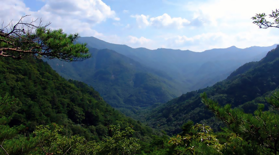
Daemi Mountain(1,115m), Munsu Mountain(1,161.5m) and Maedumakbong(1,099.5m) are famous for their beautiful sights and height, and relatively, Haseol Mountain cannot be famous because of other beautiful mountains. But natural landscape is good in this mountain.
In Haseol Mountain, you cannot miss Hasilgol. This valley is long like a long thread and the name of the valley became Hasil(thread), but later, this name was changed to 'Haseolgol'. Anciently, this was called 'Seollim' or 'Seolgol', but later, these names are changed to 'Silgol', but old villagers call this valley, 'Seolgol' or 'Seolmigol'. If you hike, you can find Neodeoljidae which has ice in summer(it is like a legend). Surely, we cannot find ice in summer but this valley is so deep so we think that it looks cold which reminds ice. It is really deep and you may find ice. Neodeol's size is 1/3 of whole Haseol Mountain.
Hasilgol section (Sungoli ∼ Peak ∼ Yonghasu) Total time for hiking: 3 hours. Time for sections: Seongori Hasilgol reservoir - (20 minutes) - Mumyeong waterfall - (10 minutes) - Three-way intersection - (40 minutes) - Anbu - (20 minutes) - Tomb - (30 minutes) - Peak - (20 minutes) - Anbu before Maedumakbong - (40 minutes) - Yonghasu (Yongha rest area)
If you go to Hasilgol, you should find Seongo1-li. On 534th local road, reservoir is there which you can easily find. One tower block the cars at the end of the road on the reservoir so you should put your car here and then you can go.
If you turn to the left side of the valley and then go up through the farm road, you can see the tunnel of the forest. You can find the right side of a steep slope and you can pass Neodeoljidae. If you turn to the left side of the valley and then go up for 20 minutes, you can find the trace of trail of the valley. If you go straight for 5 minutes from here you may cross the valley again.
If you cross the valley, you may climb the steep ridge. If you are a beginner, you cannot climb it easily. But if you are calm, you can find your sense of direction.
If you go up through Neodeoljidae ridge, you can see a certain trail at the right side and you can find three-way intersection. This is following the ridge and you can access the peak of this mountain easily.
At the center of the way to the peak, you can find Anbu and in this place, 40 ~ 50 people can rest. Also, in spring, wild edible greens are scattered in this mountain and you can enjoy these wild edible greens.
If you go straight through the valley there are many scrubs, but you can go through many scrubs and this course is also interesting.
Sasi-li section (Sasi-li Yangjimal ∼ Peak ∼ Yonghasu) Total time for hiking: 2 hours 30 minutes. Time for sections: Sasi-li Yangjimal - (1 hour 20 minutes) - Ridge - (10 minutes) - Peak - (1 hour) - Yonghasu (Yongha rest area)
If you start at Sasi-li, you should turn right from Deoksan Elementary School to Dojeon-li. If you reach Sasi-li, you can see Yangjimal across the small stream. Signboard of home visit system of Yangjimal is really big and you can find it easily. If you cross Eoksu Bridge and go to the inner Yangjimal, you can find Haseol Mountain ridge. If you cross the right side of the field, you can find the signpost.
If you start at Sasi-li and then go up to the peak, you can enjoy woods bathing on the way. In the observatory which is covered with old pine trees and Amreung, you can view Woraksan Mountain and Yongha Valley. If you start at Sasi-li and then go straight for 1 hour 30 minutes, you can reach the peak of the mountain. If you go up to the peak, you can view Daemi Mountain Munsubong and Maedumakbong and so on.
Dogili section (Yangjudong town ∼ Maedumakbong peak ∼ Yonghasu) Total time for hiking: 4 hours 10 minutes. Time for sections: Dogi-li Yangjudong town - (40 minutes) - Saemteo - (30 minutes) - Oduhyeon - (30 minutes) - Maedumakbong - (40 minutes) - 1075 peak - (50 minutes) - Peak - (1 hour) - Eoksu rest area
Yongha9gok section (Yongha rest area ∼ Peak ∼ Eoksu-li) Total time for hiking: 2 hours 55 minutes. Time for sections: Yongha rest area - (50 minutes) - Saemteo - (50 minutes) - Main ridge three-way intersection - (15 minutes) - Peak - (1 hour) - Eoksu-li