Guhaksan Mountain
Guhaksan Mountain
The name 'Nine places' means 'Crane(hak)'
The Nine Crane(hak) Mountain is located at the boundary of Chungcheongbook-do Jecheon-city Baekun-myeon, Bongyang-eup and Gangwon-do Wonju-city Sinrim-myeon. Ridge from 'Namdae peak' (1,187m) of Chiak Mountain National Park spreads to Baekun Mountain(1,087m) and south to 'Guryeockjae’ and then upheave again. Endless spirit of the ridge do not stop at 'Nine Crane(hak) Mountain' but runs ahead to south and create 'Juron Mountain(903m)' which passes 'Parangjae and Bakdaljae.' The ridge is connected to 'Sirang Mountain(691m), Myeonwi Mountain(780m), Marmi Mountain(601m)' and finally to 'Cheongpoong lake'. 'Nine Crane(hak) Mountain' has interesting origin. In the early days, nine crane(hak) lived in this mountain, but someday, these cranes(haks) winged over this mountain and people could not find them anymore. After this, people made names of places like 'Whanghak-dong', 'Sanghak-dong' and 'Sunhak-dong' which are Sinrim section, 'Haksan-li' and 'Guhak-li' which are Bongyang section, 'Unhak-li' and 'Banghak-li' which are Baekun-myeon section, 'Songhak Mountain', of Songhak –myeon and 'Whanghak Mountain' of Chungcheongbook-do Yeongdong.
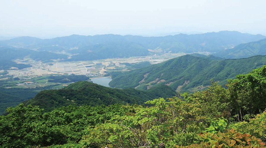
'Nine Crain(hak) Mountain' is covered with dense forests, but top of the mountain and to the west of this mountain is made of bulge rocks and you can enjoy the sight of 'Baekun-myeon' section. You can see 'Choksaebong(Sipzabong,983.2m)', 'Sambong Mountain(909.1m) and 'Baekun Mountain(1,087m)' at the northwest of this place and you can see 'Gamakbong(885.9m)', 'Seokgi rock(905.7m)', 'Yongdu Mountain(871m)' and Jecheon section which is located at the south part. Black marble stands at the top of this mountain. And planted area with Japanese larches is main attraction. In spring with sprouts of grass-green color, in summer with forests of dark green color and in autumn with golden color, the sight of this mountain is wonderful. Japanese larches which are conifer are called 'Larch' because leaves of these trees fall. And straight stem which looks like it is stretching to the sky is really good. If you go up to the ridge in autumn, you can see beautiful and huge Japanese larches which look like it is laid in golden carpet.
Juasugol section(Byeolsaekkotdol science museum ~ top of the mountain ~ Guryeockjae) Total time which is required: 3 hours 10 minutes. Time for sections: Byeolsaekkotdol science museum (Guhak mountain observatory) - (10 minutes) - The end of the forest road - (42 minutes) - Three way intersection of ridge - (5 minutes) - Tombs - (25 minutes) - Heliport - (15 minutes) - Top of the mountain - (40 minutes) - 765 peaks - (25 minutes) - Turn-off of ridge - (10 minutes) - Anbu intersection - (15 minutes) - Guryeockjae
There locates Hakjeon Elementary School and Ockjeon Church at the starting point of Juasugol at 5th national highway which connects Wonju and Jecheon. From this place to Juasugol as starting point of hiking, you may pass restaurants like 'Nomok health town' and 'Daraehyang garden' and 'Heungguksa' one of the Jogyejong temple (☎043-651-1460). You may go 4 kilometers through a valley. You can see farmhouses which is vacant now. The last stop of the bus is the ‘Nomok town’ that raises native bees.
If you go straight for about 1 kilometer, you can find 'Juasugol'. First of all, the Seventh Day Adventist Church which has green and high bell tower can be seen. 'Byeolsaekkotdol' the science museum(Guhak Mountain Observatory) is based on western style house and several buildings are made of logs. At the entrance, a stone monument which was made by Samyuk Middle School and high school stands. Behind this, six wooden houses which can be found in Europe provide pretty and superb scenery.
The main trail begins as you pass 'Byeolsaekkotdol' science museum and by following the forest road. If you go up for 10 minutes the forest road is over and you can find dense forests with scrubs. You should go up the left side of the ridge from this place. And you should be careful because this way is overgrown with bushes and a few people can find this way. 'Korea Life Mountaineering Club' is attached on the branch. If you go up through this gentle way for 40 minutes, you can find two tombs which are not treated frequently. If you go up from here for 2 minutes, you can find the intersection of the ridge which meets with the path to 773 peaks. If you pass the ridge, you can find Wonju-city Sinrim-myeon Guhak-li Keungol town. And if you want to go to Guhak Mountain, you can take the left side. There are several bomb shelters around the intersection of the ridge.
If you go up for 5 minutes, you can find 2 tombs which are well treated on the left side. Under this, you can see 'Juasugol town'. If you go straight from the tombs for 25 minutes, you can see one peak with bending ridge to the northwest, and in front of this, you can find a large heliport which the bottom is triangle. You can see concrete structure with written angle of direction towards Jecheon. If you pass the heliport and go down the right side, you can find Guhak-li Keungol town. If you go down the left side, you can find Guhak-li Jeolgol town.
You should follow the right ridge if you want to go to 'Guhak Mountain.' If you go down for 7 minute, you may reach the intersection. From the left curve of the mountain to the ridge, all paths are covered with Japanese larches. From this place to the peak of Guhak Mountain, it takes about 8 minutes. From intersection of the ridge and to the peak of the mountain, the path spreads on a soft and gentle ridge.
At the top of this mountain, pretty stone post which was made with black marbles is standing, it shows 971m. But 983m is written in topographic map of 50000: 1. At west side of the top of the mountain, rock is bulged. If you go up to this rock, you can find 'Juron Mountain' which stands at the far side towards south and you can see Japanese larches everywhere. If you go to the left side of 'Juron Mountain' and if you go down from inner side to the left side, you can find Juasugol again.
From even site of the top of Guhak Mountain to Juron Mountain, if you go there about 100 meters and then if you go down to the southwest side, you can go down to 'Baekma reservoir' following Sejeolgol. If you have a spare time, you can pass Juron Mountain and you can go from Parangjae to Jobaekseokgol Baeron shrine, Bakdaljae recreational forest, Bakdaljae and so on. Guryeockjae follows Amreung-road which is found at the northwest. If you pass 765 peaks which are risen at the end of Mujijigol, you should go towards north. After this, going up and down is continued and you can find the turn-off. If you want to go to Guryeockjae, you should go to the left side, if you pass forest of Japanese larches and if you want to go to Wonju-city Sinrim-myeon Guhak-li Whanghak-dong, you should go to the right side.
If you go down for 10 minutes, you can find intersection of the ridge which is divided into Whanghak-dong which is the right side and Baekun-myeon Banggak-li which is the left side. If you continue to go through the gentle ridge, you can see 402nd local road which passes the Guryeockjae. The way to 402nd local road of Guryeockjae from Guhak Mountain to Byeorak rock peak(937.6m) is very steep and you should be careful. It takes 30 minutes and it is 5.5 km when you go to Guhak Mountain from Juasugol and down to Guryeockjae.
[Guide point]
To find the starting point - In a large place at the left side of Juasugol, there are several wooden buildings and Seventh Day Adventists with green bell tower. Behind this, 'Byeolsaekkotdol science museum(Guhak Mountain Observatory)' is there. If you go up through the concrete paved road in front of this museum, you may meet unpaved road and if you go straight through this unpaved road for 10 minutes, unpaved road is over and you should go up through the left to the large valley.
Banghak-li section (Banghak-li Baekma reservoir ~ Top of the mountain ~ Banghak-li) Total time for hiking: 4 hours 30 minutes
Sections: Banghak-li (Baekma reservoir) - Keungol - Sonduan-Anbu - Southeast royal tomb - Top of the mountain - Keungol - Banghak-li